Nordic Summer Paradises - Part 1
A road trip from the Eifel to Northern Norway

Scandinavia is known for its very varied landscape and natural experiences. While the winters are harsh and in constant darkness, life in the summer is at its best with never-ending daylight. Mountains, lonely lakes, fells, fjords and gigantic waterfalls underline every single facet of the Nordic vegetation. There are countless outdoor opportunities to explore the Nordic world.
Around 8,500km lie ahead of us, more varied and colorful than anywhere else, towards the Arctic Circle and beyond.
We have 31 days to make sure we don't miss anything on this road trip.
A discovery tour of superlatives!
Don't miss the launch on May 30th, follow us on this website and on social media. You can already look forward to the season that will start on my channel in November.
Here we go !
Teaser - Nordic Summer Paradises
Planning in advance
This is not our first time in Scandinavia. We know from experience how inexhaustible this part of Europe is, especially for any outdoor activity. Camping and caravanning opportunities at the heart of the area are well developed and numerous.
We have been thinking about the places we want to travel to this time for many months in advance. A gigantic scope that is bursting with variety. It goes without saying that a good plan is necessary so that everything runs smoothly and without worries.
What makes a good plan: It takes all the desired elements into account, leaves enough room for flexibility along the way, and protects against unwanted surprises and time pressure. It is, so to speak, the backbone of the entire tour and enables a stress-free and exciting experience at the same time.
Our approach:
- Determination of the stations we want to travel to, including the necessary time on site.
- Determination of sensible routes between the stations with required time and path length.
- Opportunities for breaks and overnight stays on the way and selection of preferences and alternatives including contact in advance.
- Creation of a packing and loading list of all necessary utensils on the go and, if necessary, preparation of the vehicle for a safe and worry-free mobile home station.
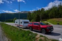
The road trip is around 8,500 km long, takes place over challenging routes and will put corresponding strain on the caravan. Of course, a preliminary check regarding tires, brakes, wheel bearings and other components is necessary, because safety comes first.
Our caravan had its brakes adjusted and some wheel bearings replaced, which were now due.
Our towing vehicle is brand new, so there was nothing to worry about.
That's it, we are prepared, can start worry-free and concentrate 100% on our tour of discovery and enjoy it!
Blog start: 30. May 2024
+++ May 30, 2024 +++
7:20 a.m., the discovery tour begins with the transfer to our first destination. We drive north via the A1 and take a break at the Lichtendorf service station, near Bremen-Brinkum, Flensburg-Harrislee and Nyborg.
Diesel fuel prices: Germany 1.63€/L, Denmark 1.69€/L.
An unusually high number of traffic jams cost us almost 3 hours of time. We compensate with shortened breaks and reach the Skanegarden rest area directly behind the border near Malmö after 950km around 11:00 p.m.


+++ May 31, 2024 +++
8:00 a.m., we set off and continue our journey. Traffic runs much more smoothly than in Germany.
Breaks in Sweden at the Hallandsas, Himle, Spekeröd and Femstenaberg rest areas.


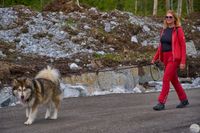
Short stop at customs at the Norwegian border: Nuki must be declared.
Fuel prices diesel: Sweden 1.56€/L
After around 680km we reach the Bergsund rest area at around 7:30 p.m., between Hønefoss and Viker on the E16.
The transfer is over, tomorrow we're off to the first stage in Valdresflye.
Valdresflye National Scenic Route
+++ June 1st, 2024 +++
8:00 a.m., we continue our journey, the first destination is the Muggedalen rest area on the E16 towards Fagernes.
Filled up quickly on the way there: 1.69€/L for the diesel here in Norway.
The rest area is located on the Begna River, a quiet and pleasant location in the middle of nature, around 200m high.


Continue into the plateau, past Fagernes. Short break in Beitostølen:
The pass is closed for the current marathon. The place is very popular with winter tourists.
We wait until 1:30 p.m. and watch the hustle and bustle.


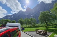
We continue via the Valdresflye to Camping Maurvangen.
The pass is over 1400m high at its highest point. We get great views and look forward to the next day to see everything in peace.
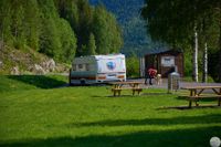
The campsite is located at the northern exit of the Valdresflye, directly on the wildly roaring Gjende River. Fantastic location, beautiful campsite, we like it here.
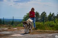
Once a year a meeting of the Norwegian dog breed Dunker takes place here. That's probably today, countless dogs of this breed cavorted here with their owners.


A short detour to Gjendesheim: Obviously a popular meeting point for hikes with great views over the Gjende in all directions. Apart from the construction activities, a romantic, dreamy atmosphere.


+++ June 2nd, 2024 +++
10:00 a.m., we set off and drive 25km from Camping Maurvangen back to Bitihorn to start our day tour. A short walk up the stairs. What a magnificent view all around.
A short time later, we drive one kilometer further north to the Batskaret Nord stop. A different perspective of the Bitihorn and Lake Vinstre in the far distance.


We jump about 4km further to Bygdin, arriving around 11:25 a.m. A nice starting point from which hikes often start.
We find a nice cafeteria at the parking lot. Parking fees can be paid online; the daily rate currently costs 80 krone, which is around €7.


12:00 p.m., we are back 2km further north at the Rjupa viewing platform. Dew water flows past here into the valley. The panorama of Lake Vinstre is also impressive. There is the very small village of Lykkjestølane with only a few houses scattered over a wide area.


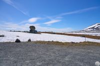
12:30 p.m., we are 3.3km further north at the Raudesteinen viewpoint at around 1400m above sea level. The place was not yet accessible to normal cars because the snow was too deep. No problem for the pickup.
The vegetation is sparse and colorful at the same time. Every single detail adds up to this great landscape spectacle. The plateau always impresses us, almost like a lunar landscape.


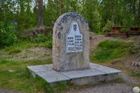
1:05 p.m., we are about 3.5km further in Fisketjerni, also known as Steinplassen. The oversized stone seems to have been placed there as if by magic, but by whom? It remains a mystery.
In the background a body of water runs down the valley.
A little further on the other side of the road we come across a small herd of reindeer.


1:45 p.m., we are 16km further and out of the plateau. We are standing at the viewing point with the imaginative name “Outlook”. A nice place to take a break and doze in the distance on Lake Sjodalsvatnet.


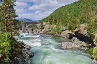
Another 6km downhill, around 2:25 p.m.: We arrive at Huldertstigen. The nature reserve can be accessed via two wooden bridges over the Sjoa River. Great panorama in this swampy area. Here too, the vegetation and the interaction with the water rushing past are impressive.
3:00 p.m., another 5km downhill: A spectacular waterfall, a must for every lover - the Stuttgongfossen. The flood rattles down the slope with an almost deafening noise, the water mist reaches up to us and cools us down.


Trollstigen and Andalsnes
+++ June 3rd, 2024 +++
9:00 a.m. - we leave from Camping Maurvangen in a northerly direction to Vagamo.
Short fuel stop, then we continue towards Otta.
Another short break at the Bekkemoen rest area, then continue towards Dombas.
First interesting stop on the way: The Romsdalen Bridge. An old railway bridge over the Rauma River.
Second interesting station: Trollveggen - In addition to a souvenir shop, there is a small wartime museum here at the train station. Surrounded by a unique and massive cliff all around.
3:45 p.m. - Arrival at Trollstigen campsite. The complex is beautifully embedded in the valley on access road 63 to Trollstigen. We are thrilled with the facility; trolls are an issue here in all situations. A small troll forest nearby entertains us in an artistic way.


+++ June 4th, 2024 +++
At around 8:45 a.m. we set off for the Trollstigen. Unfortunately currently closed due to weather conditions. Is there a happy ending? More about this from November on the YouTube channel.


2:00 p.m. - Drive to Andalsnes for city tour. We always enjoy checking out Souvenir shops, including here. This time we bought a very special souvenir, I really couldn't pass it up. What might that be? More about this from November on my YouTube channel.


Atlantic National Highway
+++ June 5th, 2024 +++
09:50 a.m. - We leave Trollstigen Camping and pass Andalsnes, first destination: The Eresfjords. We have to climb steeply uphill and downhill again over a small 500m high pass to reach the intermediate destination.
The sun is overcast, the rain is spreading. Nevertheless, the fjord impresses with its exceptional tranquility.


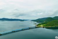
1:40 p.m. - we reach the Atlantic National Road. The rain is easing a little, the clouds remain. It is windstill.
Impressive: The impressive bridge structures, 8 in number, merge with the islands in between. Despite adverse weather - the contrast between nature and landscape architecture is noticeably in harmony. A little more sun and the panorama literally explodes.


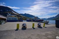
5:25 p.m. - 62km further we take a break at the Skjevlingsneset rest area. Many of the small islands along the way are connected via tunnels and bridges. This rest area is located directly at the crossing of the Bergsøysund Bridge, a long, flat bridge structure that winds across the water.


7:15 p.m. - Last stage - after another 47 km including a ferry ride from Kanestraum to Halsa we reach Camping Valsøya and spend the night.
Svartisen Glacier Nordland
+++ June 6th, 2024 +++
The sun is shining again, we start at 9:30 a.m. from Camping Valsøya towards Trondheim.
The road leads quietly through varied landscape scenes, first through the fjord area, then over mountain roads.
10:10 a.m. - Short break at the Ellingsgarden rest area.


We continue past Trondheim and Steinkjer.
2:15 p.m. - 200 km further we make a stop at the southern end of Lake Snasavatnet.
The adjacent Follingstua Camping provides access to the lake and offers great views from the campfire area.


3:15 p.m. - Overnight stopover at Vegset Camping, 40 km further north. A great facility at the northern end of Snasavatnet with a relaxed atmosphere.


+++ June 7th, 2024 +++
After a very nice evening at Vegset Camping, we set off again at 9:30 a.m. and continued north.
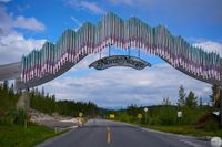
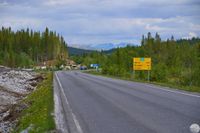
11:25 a.m. - 120 km further: We cross the border between Trondelag and Nord-Norge. The portal on the road impresses with this milestone and offers a small souvenir shop next to the rest area.
We continue on increasingly quieter roads towards Mo i Rana.
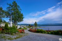
3:10 p.m. - Just a few kilometers behind Mo i Rana is the small town of Røssvoll with the campsite of the same name on the Ranaelva River. We will stay here for two nights. Tomorrow we go from here to the Svartisen Glacier.
+++ June 8th, 2024 +++
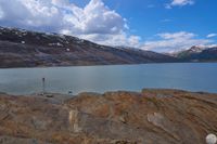
9:30 a.m. - Departure from the campsite to Svartisen Glacier. The weather looks great, sun at 13°C.
Arrive around 10:00 a.m. 14km hike, which we underestimated a bit. From the hiking car park, 4.5km along the lake through the forest, then uphill to Svartisen for around 2.5km. Then back again.
The forest was actually the much more challenging part, very swampy, densely overgrown, many streams running down the slope. Hiking height was around 90m above sea level. The subsequent climb reached around 240m above sea level.
We were rewarded with a magnificent view that is second to none. We think it's a must if you come here.
Return to the campsite around 5:30 p.m. The day is complete.


Here is the second part
Here is the third part